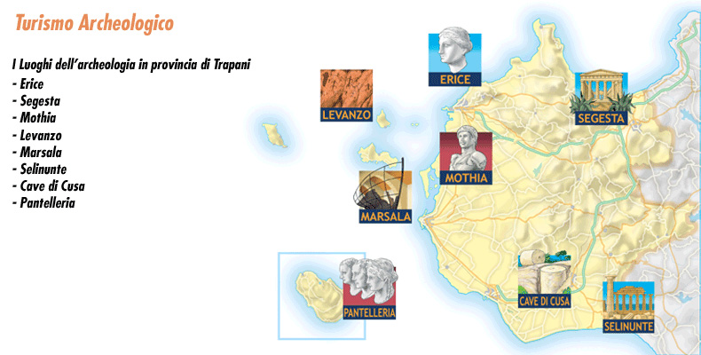
Archaeological Tourism
The province of Trapani has been inhabited since very ancient times: the Elymians, Phoenicians, Greeks and Romans have known this territory and decided to build their cities here. The position of our province in the Mediterranean, the mild climate, the amenity of the plains and plateaus, and the abundance of vegetation made this territory a perfect place for their settlement.
That is why you will find archaeological sites and excavations just about everywhere.
Inhabited here were peoples of whom we know almost nothing but who left important traces of their past. These include the paintings in the Grotta del Genovese on Levanzo and the Sesi on Pantelleria, just to name the most important. Then there were the Elymians, who built Segesta and Erice.
There were the Phoenicians, who made the small island of Mothia an important trading port.
And shortly afterward came the Romans. Of the Roman presence and their struggle with the Carthaginians there is important evidence in Marsala.
And of course the Greeks could not be missed. The finest example of their passage here is Selinunte, the great and powerful city where eight great temples were erected with material from the Cave of Cusa.
The area in which Segesta once stood is now a large, multilayered archaeological site. Here, in fact, excavations have gradually uncovered the remains of the original Elymian settlement, the Hellenistic-Roman period, the Muslim settlement, the Norman-Swabian settlement, and the medieval settlement.
The Golden Age is related to the Elymians, of whom Segesta was the most important city. However, its appearance was strongly influenced by the culture and style of the Greeks.
The city stood on two hills, on top of Mount Barbaro.
The city walls enclose two acropolis (North and South). Next to the North acropolis stands the Theater. Outside the walls are the Temple, the Contrada Mango Sanctuary and the remains of a Hellenistic necropolis.
The area is only 4 km from Calatafimi.
The archaeological zone of Segesta can be visited all year round.
In the summer period, admission is allowed from 9 a.m. to 6 p.m.
In the winter period from 9 a.m. to 4 p.m.
Admission: 6 €
Reduced ( 18 years – 25 years): 2.50 €
Free for minors and those who are 65 years of age or older.
Ticket office: 0924 952356
The Temple
The Temple of Segesta was erected on the top of an isolated hill between 430 and 420 BC. It was built in the Doric style, in imitation of the great Greek temples, although some details reveal a different origin. The most obvious difference is that Segesta lacks the cella-the beating heart of the Greek temple.
The absence of the cella and roof in the theater at Segesta have long caused scholars to debate. Some argue that the temple simply remained incomplete. Others, however, justify Segesta’s peculiarity with a political and cultural reason: the Segestans were in fact not Greeks, like their enemies in Selinunte, but Elymians. They therefore had a different religion and different customs. It is therefore possible that they built a temple, in Greek style and with Greek workmen, to compete with their bitter enemies but that, in reality, it was only a matter of appearances. Of the Elymians’ use of the temple there is no record.
The peristyle consists of 14 columns on the side and 6 in front. There are no decorations, nor can the temple be described as grand, when compared to the other temples of Magna. However, it is equally spectacular, especially since it can still be admired in its entirety.
The temple alone occupies an entire hill and is perfectly visible even from a distance.
To get there, you have to leave your vehicles a little further down and walk a short distance uphill.
The theater of Segesta
At the close of the 3rd cent. b. C., the inhabitants of Segesta built their theater on the highest peak of Mount Barbaro, on a site, behind the agora, that was already the site of a place of worship many centuries earlier.
Facing north toward the Gulf of Castellammare, it offers as its backdrop the splendid panorama of hills as far as the eye can see and a glimpse of the sea.
Built according to the dictates of Greek-Hellenistic architecture, with blocks of local limestone, it deviates from the typical structure of Greek theaters because the cavea does not rest directly on the rock but was specially built and is supported by retaining walls.
It consists of two entrances, slightly offset from the main axis of the building and is capable of holding about 4,000 people.
The cavea
The cavea is where spectators sat and still sit.
That of the theater at Segesta is 63 m in diameter and is divided in two by a central corridor, the diazoma. This results in two sections: one lower and one higher up. The first has 21 rows of seats divided by 6 ladders into 7 small wedges of varying sizes, the kerkides,.
The second was instead equipped with seats with backs. Only a few traces remain, however, of the tiers of the summa cavea.
Recent research has shown the existence also of a sector of tiers higher up, between the two entrances, which was partially reused in the Muslim necropolis (first half of the 12th century).
To the west the theater is bordered by a paved road that leads up to a natural cave, in which a sacred spring is located. Used during the Bronze Age, it was later incorporated into the retaining wall of the cavea.
The orchestra
Semicircular in shape, it is where the choir moves. At Segesta it has a diameter of 18.4 m. Entrance is allowed through two openings, the parodoi, located on either side of the semicircle, orthogonally to the central axis.
As in the theater at Syracuse, the one at Segesta has underground corridors that were used for the passage of actors.
The scene
Unfortunately, not much remains: a few rows of blocks are what we can still see of a two-story building in Doric and Ionic styles. Two advanced side bodies are decorated with satyrs in high relief.
The Selinunte Archaeological Park is one of the most extensive and important archaeological areas inEurope. Here the Doric stylehasreached one of its highest expressions, while showing local influences that enrich its architectural history.
Opening Hours and Tickets
🕘 Admission hours:
- Summer season: from 9:00 am to 5:00 pm.
- Winter season: from 9:00 am to 4:00 pm.
🎟️ Tickets:
- Full price: €6.00
- Reduced (15-18 years old): €4.50
- Free admission forEU citizens under 18 or over 65 years of age.
📍 Ticket office: ☎️ 0924 46277
The Four Areas of the Archaeological Park
Selinunte Park covers a very large area and encloses eight temples. Four main zones can be distinguished inside.
🏛 The Acropolis (to the south)
It is the most fascinating and rich part of the entire park, strategically located with mighty walls and a southern slope overlooking the sea.
TheAcropolis had an advanced urban layout and a state-of-the-art defense system. Five of the main temples were located here, including Temple C, probably dedicated to Apollo. This temple, among the oldest and most majestic, was richly decorated.
🌿 The Hill of Manuzza (to the north)
This most fertile and hospitable area was the first settlement of Greek settlers. Here themain settlement of Selinunte developed. However, in the 4th century BC, as the city declined, the inhabitants moved permanently to theAcropolis.
⛰ The Eastern Hill
Temples E, F and G are located here.
- 🏛 Temple G: one of the largest in the known Greek world. Probably dedicated to Apollo or Zeus, it measured over 110 meters long and more than 50 meters wide.
🍇 The Sanctuary of the Goddess Malophoros (to the west)
Located on the western hill, this shrine was dedicated to the goddess Malophoros, the “pomegranate bearer,” an ancient deity linked to fertility and Mother Earth.
🔹 Period of use: from the 7th century BC until the last days of the city, when it was consecrated to Punic deities.
The Selinuntine Ephebus
FromSelinunte comes theSelinuntine Ephebe, a fine bronze statuette dating from the fifth century BCE.
📍 Where is it today?
The Ephebe is kept at the Castelvetrano Civic Museum.
🏛 Civic Museum of Castelvetrano
📍 Address: Via G. Garibaldi 50, Castelvetrano
☎️ Phone: 0924 908893
🕘 Opening hours:
- Monday – Saturday: 9:00 a.m. – 1:00 p.m. and 3:00 p.m. – 6:00 p.m.
Eleven kilometers from the city, there is the place from which the Selenuntines took the material needed for the construction of their majestic temples: the Caves of Cusa.
Only there did they find tuff hard enough to be worked into large blocks.
The quarries were used for a very long time, and the work probably involved a large number of people.
The size of the tuff blocks required the application of a special method: the blocks were dug directly into the rock and worked on site. Only afterwards were they transported.
The peculiarity of the Quarries of Cusa is that they were abandoned suddenly, in 409 B.C., because of the arrival of the Carthaginians who would destroy Selinunte.
Thus, even today, it is possible to see the walls of the quarries carved by the tools of the Selenuntines, some stone blocks left in the process of being worked while others, scattered here and there, had already been detached from the rock and were ready to be taken to the city. There are also some of them on the road leading to Selinunte.
A visit to the Cave of Cusa thus makes it possible to reconstruct the entire cycle of extraction of the raw material used here between the 6th and 5th centuries BC.
Pantelleria was probably frequented as early as the Neolithic period (fifth millennium B.C.). The island was very rich in obsidian, one of the earliest materials used for making objects, and this attracted nearby populations here.
The earliest evidence of a stable community, however, dates back only to the second millennium B.C.E.: this is the Village of Mursia with its adjoining necropolis.
The Village of Mursia, on the northwestern coast of the island, is located in an area that is, in part, naturally protected by the overhang of the sea. A mighty wall was erected to complete the defense. The remains of circular huts equipped with millstones and basins for collecting water remain in the village.
The same people who built the huts and fortifications also created a necropolis. Funerary monuments called Sesi were built here.
The structures resemble others created in similar Mediterranean environments. They are circular constructions, full on the inside, with hollows on the sides that were used for burial rites.
From the 9th century B.C. the Phoenicians arrived on Pantelleria. To them we owe the Acropolis of San Marco and the Temple of the Lake of Venus.
The Acropolis of San Marco has recently undergone excavation campaigns. You will be able to see traces of fortifications, large water cisterns and numerous architectural elements: ancient Cossyra stood here. The cistern system is particularly interesting: it was this that enabled the island’s inhabitants to collect rainwater, thus solving drought-related problems. Also in the area were three perfectly preserved Roman portraits. The first two, found inside the same cistern, depict Julius Caesar and a female figure of noble rank. The third, found in a different cistern, is a portrait of Emperor Titus.
On the eastern shores of Lake Venus are the remains of a Temple from the Punic period. The structure, including a portico, is leaning against the rock face. It probably consisted of several buildings that directly overlooked the lake. Foundations of later Hellenistic-Roman reconstructions are also visible. A lot of ceramic material was found in the area: this suggests the use of the temple for quite a long time.
On the eastern side of Scauri Bay a large number of ceramic fragments from different periods, traces of warehouses and a kiln have been found. The presence of a villa dating from the 4th – 5th centuries AD has also been identified: a structure with living purposes to which large cisterns are attached. To these also belong some valuable architectural elements and mosaic fragments.
Gadir Cove: In ancient times Gadir was a busy port of call. This explains why its seabed is a very rich mine of artifacts. From there comes a copious collection of amphorae from the Punic period. In the same area, the fragments of two wrecks dating from the late 3rd to early 2nd centuries B.C. and the late 2nd to early 1st centuries B.C., respectively, have been identified.
An underwater archaeological itinerary has been created that allows divers to admire ancient artifacts directly on site, between 18 and 30 m. deep.
Port of Scauri: The Port of Scauri, in the southwestern part of the island, is a bay well protected from the winds. The remains of a wreck, sunk around the end of the 5th century AD, were found here. A wide area between 6 and 10 m. deep, it is rich in pottery, both intact and in fragments, and various kinds of everyday objects.
Arenella: The stretch of sea in front of the Arenella locality contains many ceramic artifacts and cylindrical amphorae from the late imperial age.
Mothia was an ‘important Punic trading port. The remains of its civilization and thriving economic activity have been unearthed by a long series of archaeological excavations, largely due to the work of Joseph Whitaker, who had previously purchased the island.
The Whitaker Museum – His home today houses the museum that collects artifacts unearthed during various excavation campaigns.
A model will first show you the entire island of Mothia so that you can more easily locate sites of major historical significance.
The museum preserves a wealth of artifacts from prehistoric times, materials found in the settlement, funerary furnishings from the Thofet and Archaic necropolis, ceramics, coins, sculptures, jewelry and votive stelae.
A great boast of the island, it is the famous Youth of Mothia.
The 1.81 m tall white marble statue from Anatolia is missing its limbs. There are still many doubts about its origin and the subject depicted. However, the tunic and complex hairstyle suggest a high-ranking subject. The author, if not Greek, was nonetheless influenced by the Greek “severe style” and possessed an uncommon plastic sense. The proportions are harmonious and elegant. Very beautiful is the pleated and well-drawn tunic on the body. It probably dates from the 5th century B.C.
The island is easily traversed on foot.
The thick vegetation in the interior makes for a pleasant visit.
While walking you will encounter:
The House of Mosaics: two mosaics from the 4th century B.C. formed of black and white pebbles depicting animal fight scenes.
The Cothon: small dry dock with a rectangular shape
Remains of fortifications: although its geographical location was already a natural protection, starting in the mid-4th century and through later interventions, the city was surrounded by walls. Some remains of these can be seen to the north and south. Some of the towers placed along the perimeter are also visible.
Cappidazzu shrine: the area includes buildings from various periods whose use is still unknown. However, the presence of some altars suggests a sacred place intended for offerings to deities.
The Thofet: sacred area where firstborn males were sacrificed to the gods. Numerous votive stelae have been found here.
Getting to Mothia –
From the landing stage located near the Marsala Salt Pans, the special service between the island and the mainland departs.
The mighty wall of Elymian (8th-6th cent. B.C.) plan once surrounded the northeastern side of the city, the only one exposed to attack. To the large, older blocks that characterize the lower part, an elevation of smaller ashlars was added in later periods. The walls had watchtowers, a walkway accessed by steep steps and small openings that allowed the passage of inhabitants and perhaps supplies. The best preserved section runs along Via dell’ Addolorata, from Porta Carmine to Porta Spada.
The Genovese Cave in Levanzo holds a treasure of inestimable historical and artistic value. Inside the cave, a hidden ravine, more than 8 meters wide, has walls covered with graffiti and cave paintings.
In the lowest part are the graffiti. These date from the final phase of the Upper Paleolithic and depict mainly animals, especially horses, cattle and deer. There are few human figures. The subjects are depicted in profile, with a single stroke, in a strongly naturalistic style.
In contrast, in the upper part of the wall are paintings dating from the final phase of the Neolithic. They depict threadlike, stylized bodies in black. These include a tuna and a dolphin-the earliest known representations of fish in Europe.
In the same cave, pottery and flint knives have been found.
It is possible to visit the Genovese Cave throughout the year. It is located about 5 km from the town. The opening gives onto a small balcony overlooking the sea.
It is possible to visit the cave by contacting the guide and booking the visit in advance: in this way you can reach the cave by off-road vehicle, together with the guide.
During the summer period it can be reached by boat, combining the visit with a tour of the island.
For guided tours: 0923 924032
Baglio Anselmi Archaeological Museum
A wine-making establishment from the last century is now the site of the museum that houses archaeological finds unearthed during various excavation campaigns between Marsala and Mothia.
This is a sizeable collection of ceramics, amphorae, funerary furnishings, votive stelae, furnishings and jewelry, architectural elements and various types of objects.
A fine mosaic from the Roman insula is also preserved here.
The museum also boasts the presence of the Venus Callipigia and the Punic Ship.
The recently found Venus Callipigia, despite being missing her limbs and head, immediately attracts the visitor’s attention by her soft, elegant form and drapery, which instead of covering her, enhances her nudity.
Punic Ship of Marsala
The Punic Ship is an important record of the ancient wars that Romans and Carthaginians fought in these waters. The wreck probably sank during the Battle of the Aegates that ended the First Punic War in 241 BC. The ship has been reconstructed inside the museum: the port side and the stern side are clearly visible. Along with the ship, part of the cargo was also recovered.
Lungomare Boeo – Marsala
Tel: 0923 953614
Roman Insula in Marsala
The Roman insula of Cape Lylibeo covers a rather large area, formerly bounded by two paved streets. It is a luxurious dwelling with an attached thermal facility. The frigidarium ( cold-water facility) and caldarium (hot-water section) are clearly visible.
Also of note is the mosaic pavement.
The insula is located in the vicinity of the ancient decumanus maximo, the main street of Roman times, which started from the Capo Boeo promontory and ran along what is now Via XI Maggio.
Marsala is a place of continuous archaeological discoveries. You will find excavated areas just about everywhere. These include that of the former monastery of San Gerolamo, which flanks the Oratorium Santa Cecilia, and the 4th-century moat at the end of Via Amendola.