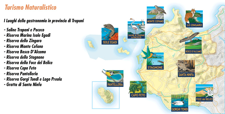
The Oriented Nature Reserve Saline di Trapani e Paceco extends in the territory between the cities of Trapani and Paceco, precisely from the southern area of the capital to the hamlet of Salina Grande. Here, centuries-old structures created for salt processing have harmoniously integrated with the natural landscape, creating a unique and deeply evocative environment.
It is one of the few examples where human productive activities have not only not damaged the original environment, but have enriched it with a special touch. The beauty of the reserve is most strikingly manifested at sunset: when the sun goes down, each pool reflects different hues, from deep pink to red and golden. In those few moments before the light fades, one witnesses a magical spectacle, with colors and shades that seem to chase each other.
Established in 1995, the reserve was created with the aim of protecting one of the last remaining wetlands in western Sicily. Today its 986 hectares, divided between reserve and pre-reserve, are entrusted to the care of WWF Italy.
🔗 For more information, please visit: https://wwfsalineditrapani.it/
Managing entity
🌿 WWF Italia – O.N.L.U.S.
📍 Address: Via G. Garibaldi No. 138, C.da Nubia, Paceco (TP)
📞 Tel/Fax: +39 0923 867700
Getting there
✈️ By plane
Trapani/Birgi “Vincenzo Florio” Airport: follow SP 21 in the direction of Trapani to the Maria Stella mill.
🚗 By car
- From Trapani: follow SP 21 in the direction of Marsala to the Maria Stella mill.
- From Palermo: take theA29 Palermo-Mazara highway towards Trapani, follow the signs to the port, then take SP 21 to the Maria Stella mill.
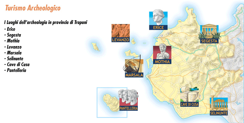
Facing the Trapani coast is theEgadi archipelago, which at 524 km² constitutes the largest Marine Nature Reserve in the Mediterranean . It includes three main islands-Levanzo, Favignana and Marettimo-andtwo uninhabited islets, Formica and Maraone.
Three islands nestled in a sea of enchanting hues, with beaches and rugged coastlines. Places where time seems to flow differently, inhabited by a few people and enveloped in a unique atmosphere. But it is above all in the depths of the sea that the real magic lies: staring at it for a long time is not enough to dampen the amazement of the first glance.
The archipelago offers an extraordinary variety of environments, shaped by the combined action of wind, geological features, and hydrodynamic and morphological conditions. A paradise for those who love the sea on the surface and even more so for those who wish to explore its submerged secrets. Small inlets where access is reserved for the few and a myriad of caves, some accessible by boat, others accessible only to divers.
Colors, smells, tastes and sounds that speak a different language from that of the cities. Here the awakening begins with a simple question, “Which way is the wind blowing today? What will the sea be like?”
Marettimo
Furthest from the coast, Marettimo is a wild and fascinating island. As soon as you disembark, even before you realize that the entire town is gathered in the one spot where the mountain dips gently into the sea, you will run into the fishermen. They are waiting for you with their boats, ready to offer you a tour of the island-a not-to-be-missed experience.
They will take you on a tour of the sea caves, telling you the stories and peculiarities of each one. Watch the water: with every meter, the sea changes hues, while the mountain walls plummet sheer into the blue.
In only one place on the island has man been able to settle: right where the town stands today. The rest is mountain and sea, the two souls of the island, hence its name: Mare-timo.
Perhaps you will stop at Cala Bianca, and you will surely pass by the Castle of Punta Troia. The locals will tell you about Marettimo with the simplicity of those who live there, and ask you where you would like to stop: there are no beaches here that are easily accessible from land, only small coves accessible by sea.
Don’t expect discos or big clubs: there are only a few bars and small restaurants here. Here you live by nature alone.
Favignana
The largest and most famous of the three islands, Favignana comes closest to being a real town. Known as “the butterfly on the sea,” it was for centuries the queen of the tuna fisheries, when tuna slaughter brought fortune to the Florio family.
The island boasts crystal clear waters and amazing scenery at every turn: Cala Azzurra, Cala Rossa, Cala Rotonda, and countless nameless coves.
Your task will be to find out which one you like best. You can choose from white beaches, small coves surrounded by rocks, rocks from which children dive with perfect somersaults, and breathtaking seabeds perfect for diving enthusiasts.
Levanzo
Green and mountainous, Levanzo is the smallest of the Egadi Islands, but it boasts a worldwide reputation thanks to the Genovese Cave, where paintings and graffiti dating back to the final phase of the Paleolithic period are found.
Guided tours allow visitors to admire ancient depictions of humans, animals and fish, dating from between 10,000 and 15,000 years ago.
Managing Entity
🏛 Municipality of Favignana
📍 Address: Europa Square, Favignana (TP)
Between Castellammare del Golfo and Trapani lies one of the most striking corners of Sicily: a dreamy oasis nestled in the typical Mediterranean landscape, reached by ancient, narrow paths that wind through evergreen trees and shrubs on rocky ground.
Facing the spectacular scenery of the Zingaro, it is impossible not to marvel at every step: towering walls of limestone rock rise above lush vegetation, then plunge sheer into a crystal-clear sea. It is as if they, too, are captivated by the beauty of these waters, which fade from turquoise to deep blue and emerald green.
Here, the sea is so clear that the seabed can be discerned even with the naked eye. Its waves gently caress the white beaches of small coves as they creep into submerged caves, revealing and concealing a teeming world of fish and sea plants.
The reserve’s lush vegetation has become a refuge for numerous birds and mammals, some of them rare. The coves scattered along the coast are popular destinations in the summer months for those seeking a place to regenerate body and mind in a pristine and protected environment.
This land has existed for millennia, defended and shaped by its rugged and bristling rocks, colored by the deep green of the local flora and the deep blue of the sea. Shepherds and farmers have lived and worked it, exploiting it without ever destroying it. Thanks to this respect, today its 1,600 hectares of protected area and 7 km of coastline are a true natural paradise.
Fun at the Gypsy
🌿 Hiking and trekking: the reserve’s long trails are perfect for nature lovers and scenic walks.
🌊 Diving and snorkeling: underwater caves and spectacular seabed offer a unique experience for divers.
🍽️ Picnic areas: equipped spaces for those who want to spend a relaxing day.
🏛️ Museums: the Museum of Maritime Activities and the Museum of Peasant Civilization tell the story and ancient traditions of these places.
🦜 Birdwatching: a must-do activity for avifauna enthusiasts.
Entrance to the Reserve
There are two entrances to the reserve:
🔹 South from Scopello-main entrance with accommodation facilities.
📍 Directions: Take the A29 Palermo-Mazara highway to the exit for Castellammare del Golfo, then follow the SS 187 in the direction of Trapani to the junction for Scopello.
🔹 North from San Vito Lo Capo – alternative entrance.
📍 Directions: Reach SS 187, as indicated above, and turn at the junction for San Vito Lo Capo.
🅿️ In both cases, you must leave your vehicle in the dedicated parking lots and continue on foot.
Rates and Opening Hours
🎟️ Admission tickets:
- Adults: €3.00
- Children (10-14 years old): €2.00
- Groups: €0.50 per person
- Children under 10 years old: free of charge
🕗 Opening hours:
- October – March: 8:00 a.m. – 4:00 p.m.
- April – September: 7:00 a.m. – 8:00 p.m.
🔗 For more information: www.riservazingaro.it
Pathways
There are several hiking routes within the reserve, some running along the coastline, while others lead inland, amidst breathtaking views and glimpses of rare beauty. You can choose routes of varying difficulty and duration, depending on your needs and level of experience.
The shelters
🏡 Where to sleep in the reserve
In Contrada Sughero, within the reserve, there are shelters where it is possible to stay overnight with prior reservation, in the period between October and May.
📞 Info and reservations:
🔗 www.riservazingaro.it
📞 Tel: 0924 35108
The Mount Cofano Oriented Nature Reserve, located in the territory of Custonaci, covers 537 hectares in a unique geographical position. Here, where the Gulf of Bonagia and the Gulf of Cofano meet, rises a striking promontory jutting out toward the sea, dominated by Mount Cofano, which reaches a height of 659 meters.
This reserve deserves its title for its great naturalistic, speleological, historical, folkloristic and scenic value.
Lush Mediterranean vegetation interrupts the rugged, wild forms of the Dolomite massifs, while the slopes of the mountain are home to numerous caves, inhabited since the Paleolithic era and now the scene of Custonaci’s evocative Living Crib. Further downstream, watchtowers tell of a time when the Sicilian coasts must have been defended from pirates, while the remains of an ancient tuna fishery testify to the historical importance of tuna fishing in this area.
Finally, the beauty of the landscape is perhaps what most excites visitors: from the top of the mountain, for those who have the will and patience to reach it, the sea is revealed in all its immensity, appearing even bluer in contrast to the green vegetation that frames it in the gulf.
The Caves
The walls of Mount Cofano are home to numerous caves, of great geological and paleontological interest. Fossils, tools and graffiti have been found here, evidence of human presence since the Upper Paleolithic.
Of them all, the most famous is the Grotto of Scurati, located near the hamlet of the same name. Every year, this cave becomes the stage for the famous Living Crib, where the local people re-enact the atmosphere of the Nativity in a unique setting.
The Paths
🥾 Coastal Trail
A pleasant scenic trail follows the coastline, allowing for a relaxing walk along the entire circumnavigation of the headland. The full trail takes about 2 hours to walk, but it can also be walked in parts.
⛰️ Trail to the summit of Mount Cofano
A more challenging trail leads to the summit of the mountain, giving a breathtaking view of the Gulf of Cofano. The climb requires agility and a good physical condition, as it involves passages between rocks. The route can take about 3 hours, depending on the starting point. It is not recommended during the hottest hours of the summer season.
Managing Entity
🌿 Regional State Forestry Company
📍 Address: Via Libertà 97, Palermo
📞 Tel: 091 7906811 – Fax: 091 7906801
How to get there
🚗 From Palermo
- Take theA29 in the direction of Trapani.
- Exit at Castellammare del Golfo and take SS 187 towards Trapani.
- Turn at the junction for Custonaci and continue toward Scurati.
🚗 From Trapani
- Drive along the Torrebianca/Valderice provincial road and take SS 187 towards Trapani.
- Turn at the junction for Custonaci and continue toward Scurati.
A microcosm under the sun…
Suggestive and sensual, the Stagnone Oriented Nature Reserve extends, within the territory of Marsala, for a long stretch from Cape Lylibeo to San Teodoro.
We are talking about a very special place: from a zoological point of view, it represents a natural laboratory in which new organisms form and evolve before confronting the open sea. The only European environment to have such a privilege, it deserves special respect for this.
The name of the Reserve refers to the fact that the large stretch of sea involved is separated from the rest of the Mediterranean by a large natural breakwater, Isola Grande, which makes its waters placid and calm.

Within the lagoon is a small archipelago of islets: isola Grande, Mothia, S. Maria and the small rock of Schola, so named because of the popular belief that in Roman times there was a school of rhetoric there.
The sea here remains very shallow so that it is possible to walk along it for long stretches without its level exceeding knee height. At its deepest points the water reaches 3 m. but from S. Teodoro it is also possible to reach Isola Lunga on foot, and until a few decades ago carts and horses plunged into the water to reach Mothia.
In summer it is easy to see someone windserf or canoeing there, precisely because of the fact that the shallow, calm waters guarantee total safety even for beginners. Some people also swim there: this body of water, with its high salinity, gets pleasantly warm in summer, with temperatures unusual for other parts of the area.
You will only have to look at the Stagnone from the shore to fall in love with it: the road runs right next to the water and a walk by bicycle, or if you prefer by car, will allow you to observe the islands, all beautifully displayed next to each other, the shallow and calm water, the clumps of wild vegetation growing here and there and, finally, the salt pans with their windmills.
The Stagnone Reserve is indeed a wonderful combination of nature, history and human action that have merged together to create a unique and breathtaking landscape.
The island of Mothia holds numerous archaeological finds from the time when its Mediterranean location had made it such an important Phoenician trading port that it harmed Dionysius of Syracuse, who destroyed it in 397 BC.
The salt pans are one of the oldest and most productive activities in this area to which nature has bestowed a perfect climate for collecting salt from its waters, letting it dry with the heat of the sun and the force of the wind, so that passersby are given the opportunity to enjoy the spectacle of those huge white mountains behind which the sun goes to sleep while, just beyond, the silhouettes of small islands peep out.
To reach Mothia there is a special service several times a day that leaves from the special landing stage at C/da Spagnola in Marsala.
Managing body
Regional Province of Trapani
Via Vito Carrera 23
Tel: 0923 873678
FLORA & FAUNA.
Flora
The spontaneous vegetation that enriches the reserve is quite varied and owes its survival to the motion of the tides thanks to which the effects of the shallow depths and high summer temperatures are weakened, which, in themselves, would make all forms of animal or plant life impossible.
Its protection is of considerable importance because it is part of a larger project to safeguard the entire triangle between Trapani, the Egadi Islands and Capo Feto, which is the marine belt where Posedonia oceanica, an underwater palmetto that lives only in extremely clean waters, is found. In some stretches, it forms small atolls that are home to numerous other animal and plant populations. Other species of Posedonia are found only in Australia.
The Stagnone also possesses a rare peculiarity: in its waters strangely enough, species that outside of here would be incompatible, that would struggle with each other for survival, or that simply belong to different ecosystems can coexist.
Areas with higher salinity are home to Suaeda maritima, Salicornia, Salsola soda, and Limonium of the salt marshes: all halophilic species, capable thanks to very specialized physiological mechanisms, of resisting high salt concentrations. On accumulations of Posidonia deposited by the sea along the coasts one can find Calendula maritima, a herbaceous seedling with yellow flower heads found exclusively in western Sicily.
Where brackish water makes its effects felt less, Rush andInula develop.
In the innermost parts of the islands, Mediterranean scrub with thermophilic species such as Lentisk, Dwarf Palm, Red Cistus, and Prickly Asparagus develops. OnIsola Grande andIsola di S. Maria, groves of Aleppo Pine were planted a few decades ago.
Vines are still grown in Mozia, and on the tiny Schola it is common to see Ferula, a tall herbaceous plant with feathery leaves and large yellow flowers.
Fauna
When migratory birds return from Africa to Europe, they take advantage of the wet, and therefore food-rich, environment of the Stagnone to refresh themselves a bit.
Birds-The Stagnone reserve and that of the Trapani and Paceco salt pans have now remained among the few oases of well-being to be found on the path of the Great and Little Corsairs, the Fratino that hides its eggs among the Posidonia leaves, the Black-winged Stilt and Avocets that breed here.
As early as July, the Stagnone hosts autumn migrants: Curved-billed Curlews and Nightingales with their dark plumage. Then with the cold weather come flocks of Ducks with Marsh Harrier waiting in ambush, Moriglioni, Teal, Coots, Mallards, Pintails and Garganeys.
Splendid is the image of the Herons, superb and haughty, intent on searching for food among the salt ponds. It will not be difficult for you to catch a glimpse of Grey Herons, white Egrets, Cormorants, elegant Spoonbills that will leave the Stagnone only in the spring, and even Kingfishers, which when they open their wings show all the beauty of their sky-blue livery.
There is also no shortage of Kestrels, famous for their swooping flights over prey, and the Osprey, skilled in diving into the water. Finally, the brackish coastal environments allow the survival of a small butterfly, the Phoenician Lycena.
Fish – The fish fauna of the Stagnone is different depending on the area under consideration.
In particular, we distinguish between two areas: the first one, in the south, has more possibilities of communication with the open sea while the second one, in the north, hosts life forms more closely related to lagoon environments.
That is why in the first one live Saraga, Bream and Mullet and in the second one only smaller fish with a short life cycle.
In the province of Trapani, there is an island that leans more toward Africa than Sicily: a paradise of colors, scents and flavors, characterized by rugged and wild landscapes, precisely for this reason fascinating.
What is immediately striking is the strong color contrast, which also reflects the diversity of its atmospheres:
🌿 The deep green of the valleys and vineyards.
🌊 The clear blue of the sea.
🖤 Thedark anthracite of the lava flows.
🍇 Thebrilliant gold of the clusters of zibibbo grapes.
🏡 The dazzling white of the dammusi, the typical Pantelleria dwellings.
🌞 All wrapped in the boundless blue sky.
The island is a natural and cultural mosaic, where every corner hides a wonder:
- The coves, perfect for bathers.
- Steam jets and hot springs, a sign of its volcanic origin.
- The Mirror of Venus, a lake with an evocative name, famous for its sulfurous mud.
- Vine crops, which residents have always preferred to fishing.
- Dammusi, buildings of Arab origin with domed roofs and thick walls, designed to protect against the heat of the sun.
An island between history and nature
The town, where one arrives by sea or plane, has unfortunately lost some of its original charm due to the bombings of the last war. However, you only need to travel a few kilometers to find yourself in a completely different world, far from the time and hustle and bustle of modern life.
The nature reserve stretches from the center of the island, dominated by Big Mountain, to the coast. The main relief is surrounded by a series of smaller volcanic rises, called “cuddles.” To them we owe the very existence of Pantelleria: the overlapping of lava flows, dating from different eras, has created a unique landscape.
The northern part, formed by more recent volcanic activity, is characterized by gentle, even slopes, interrupted only by a few lava cones. It is also home to the Specchio di Venere (Venus’ Mirror), a true natural beauty farm, with thermal mud and sulfur springs, ideal for regenerating and enjoying the beneficial properties of nature.
An island rich in history and culture
The things to see, experience and savor in Pantelleria are endless, as are the breathtaking views that everyone can elect as “the most beautiful.”
As in many corners of Sicily, history has left indelible traces. The island has been the crossroads of many civilizations, and even today the signs remain:
- Neolithic burials, the legacy of a people who came from Tunisia.
- The names of the districts, which resonate with Arabic echoes.
- The Balata dei Turchi, memory of defeated pirates.
- And much more…
📍 Pantelleria is an island far from the rest of the world, but very close to the heart of those who visit it.
Managing Entity
🌿 Azienda Foreste Demaniali of the Sicilian Region
📍 Forest Detachment C.da Sibà – Pantelleria
📞 Tel: 0923 916524
The Bosco d’Alcamo Oriented Nature Reserve extends over the summit of Mount Bonifato, covering an area of 314 hectares characterized by dense vegetation.
In the 19th century, this area was covered by a deciduous forest, which later disappeared due to indiscriminate human exploitation. Beginning in the early twentieth century, a long process of reforestation, which lasted about 60 years, began, resulting in the present forest.
One of the most interesting aspects is that, alongside the artificially planted vegetation, native broadleaf species have spontaneously developed, witnessing the original vegetation of the mountain. This process has created an ecosystem that is still settling, gradually approaching a natural balance.
The Castle of Ventimiglia
Hidden among the trees of the reserve are the ruins of an ancient medieval village, creating an evocative atmosphere. The top of the mountain, rich in water and strategically positioned to control the Gulf of Castellammare, has been inhabited since ancient times. The Elymians settled here after conquering Segesta.
Today, the lush greenery blends harmoniously with the remains of medieval walls, ancient dwellings, water cisterns, and the Castle of Arab origin, restored in 1397 by Henry of Ventimiglia.
Of the four towers that once protected the castle, the best preserved is the northwestern tower, 19 metershigh and structured on three levels, with a barrel vault. Also on the north side, the jambs of the Queen’s Gate, one of the main entrances to the ancient settlement, can be seen.
La Funtanazza
Outside the city walls is “La Funtanazza,” an ancient medieval reservoir that collected water from a spring above.
Thanks to an advanced architectural technique for the time, the structure was covered by an ogival vault, supported by four arches.
Itineraries in the Reserve
🏺 Archaeological Trail
📏 Length: various
⏳ Walking time: variable
⚠️ Difficulty: medium
The trail passes through the medieval ruins of Bunifat, on the summit of Mount Bonifato. Along the way you will encounter:
- The Funtanazza, an ancient water reservoir.
- Queen’s Gate, the main entrance to the settlement.
- The ancient medieval dwellings and cisterns (12th-13th centuries).
- The defense towers on the east and southwest slopes.
- The mighty boundary wall, about 2 meters wide.
- The snowfields, once also used as water reservoirs.
- Ventimiglia Castle, with its main tower still well preserved.
🌸 Orchid Trail
📏 Length: 850 meters
⏳ Walking time: 1 hour
⚠️ Difficulty: low
This trail runs along the western slope among domestic pines, Aleppo pines, cypresses and ash trees, from which manna was once extracted.
The low density of trees allows for greater soil insolation, promoting the growth of diverse vegetation, including:
- Ogliastro, used for making woven baskets.
- Blackthorn, known for its medicinal properties.
- Butcher‘s Broom, the roots of which are used in infusions and distillates.
📌 The trail is home to as many as 28 species of orchids, which bloom between August and October.
🌿 St. Nicholas Trail
📏 Length: 1800 meters
⏳ Walking time: 2 1/2 hours
⚠️ Difficulty: medium
This trail offers spectacular panoramic views of inland Sicily. Along the trail are:
- Judas, lentisk and terebinthtrees, from which the resin known as Chian mastic is extracted.
- Mediterranean garrigue, with dwarf palms, ferulae and capers.
- Brooms, whose deep yellow color stands out among the green.
- Aromatic plants such as oregano, wild mint, and wormwood.
At altitudes above 500 meters, the vegetation changes: arborescent spurge and acanthus, typical of this elevation range, appear.
Reserve Services
- Area equipped with barbecue and stone tables.
- Forest acrobatic trails.
- Hostel and refreshment point.
Environmental Education Center (CEA) – Vivilbosco
ATI Vivilbosco, in collaboration with CEA Sicilia, is engaged in the enhancement of the RNO Bosco d’Alcamothrougha rich program of activities:
- Educational workshops on biology, geology, botany and zoology.
- Residential school camps, with educational experiences in nature.
- Hiking, trekking and birdwatching, guided by experts.
- Research projects on the flora, fauna and archaeology of the area.
- Library specializing in environmental issues.
📞 For more information:
🔗 Website: www.boscoalcamo.it
📧 Email: info@boscoalcamo.it
📍 Address: Via per Monte Bonifato/Funtanazza
📞 Tel: 328 9890361 | 0924 202626
📠 Fax: 0924 202625
🗺 GPS coordinates:
📍 37°57’33” N – 12°57’38” E
Sand, dunes that change disposition with the wind and amber colors of desert space: it seems to be in Africa and instead we are in Sicily, in the Oriented Nature Reserve that affects the terminal part of the Belice River and the surrounding dunes.
It is a landscape now rare in Sicily that covers 4 km of coastal area between Marinella di Selinunte and the promontory of Porto Palo: an area that covers 241 hectares, of which 129 hectares of actual reserve separated from the remaining 112 hectares of pre-reserve by a disused railway line.
The innermost part, where the dunes are located, is rather arid while the river bank makes the surrounding area more humid, with large temperature ranges between day and night, sometimes subject to sea flooding.
In the southernmost part of the province of Trapani, west of Mazara del Vallo, lies one of the last surviving wetlandsin Sicily. A place of community importance, recognized for its ecological value and subject to special protection.
TheCapo Feto Protected Area covers about 453 hectares, characterized by sand dunes and small bodies of water. It is awide depression, separated from the sea by a sandy cordon, which changes its appearance with the seasons:
- In winter, it is almost entirely waterlogged.
- In summer, it appears drier and drier.
Between 1999 and 2002, the marshes of Capo Feto were the subject of a European Life – Nature project aimed at the reintroduction of species that had disappeared in their historical ranges.
Unfortunately, prior to these interventions, the area had suffered from indiscriminate human exploitation, which was endangering its ecological balance and survival.
A sunken archaeological treasure
In 2006, the area underwent an underwater archaeological excavation campaign, which uncovered shipwrecks probably dating back to the 4th-3rd centuries BC. These finds represent valuable historical evidence of trade routes and navigation in antiquity.
To find a treasure, you have to look for it. And if you want to discover the Lake Preola and Gorghi Tondi Integral Nature Reserve, you have to get closer.
When you least expect it, nestled in a valley hidden from prying eyes, there it appears: a series of small lakes, spread over 335 hectares of land that, starting from Mazara del Vallo, extends toward Torretta Granitola, running parallel to the coast for about 1 km.
Coming from Mazara del Vallo, the first body of water you will encounter is Lake Murana, unfortunately dry for some time. Only after that, you will be able to admire Lake Preola, the largest, followed by the three Gorghi (Upper, Middle and Lower), characterized by a circular shape and surrounded by dense marsh vegetation typical of Mediterranean coastal ponds, with weakly brackish waters.
On the southern slope, the area is dominated by limestone ridges, partly covered by Mediterranean scrub. This depression is of karst origin, shaped by theaction of water over time, which has eroded the chalky soil to create these natural bodies of water, now valuable habitats for numerous animal and plant species.
Trails and Nature Trails
The reserve can be visited all year round with prior reservation, but spring is undoubtedly the best time to admire it in all its beauty. That’s when nature awakens after the winter and the birds cross the sky, creating a magical atmosphere.
WWF, the reserve’s managing agency, has built a Visitor Center with a multimedia education room and two equipped trails with observatories on Lake Preola and Lower Gorgo.
🔹 Lower Gorgo Observatory
- Also accessible to people with disabilities.
- Reached by a 180-meter path surrounded by Mediterranean bush.
🔹 Lake Preola Observatory
- It allows numerous species of aquatic bird life to be observed, especially in spring, when birds nest among the reeds surrounding the lake.
📍 Main Trail
The trail begins at the point where the Gorghi Tondi Provincial Road crosses, via an embankment, the three karst lakes. It is from these bodies of water that the road gets its name.
Managing Entity
🌿 WWF Italy
📍 Address: Via Maccagnone 2/B, Mazara del Vallo
📞 Tel: 0923 934055
🔗 Web site: www.wwflagopreola.it
How to get there
🚗 By car
🔹 From Palermo (A29 Palermo-Mazara del Vallo).
- Exit at the junction for Campobello di Mazara.
- Drive along the SS 115 in the direction of Trapani until Km 57.
- Turn onto Provincial Road No. 85 and follow the signs.
🔹 From Mazara del Vallo
- At the end of Via Castelvetrano, take SS 115 in the direction of Campobello di Mazara.
- Before the highway viaduct, take Provincial Road No. 85 and follow the signs to the reserve.
In the heart of western Sicily, between the towns of Santa Ninfa and Gibellina, lies a unique and fascinating landscape, shaped over millennia by water and time.
Tall, white rocks, marked by deep perpendicular grooves, emerge among the green valley, adorned with the typical crops of this land. These are the karren, furrows carved by the slow action of rain. The landscape is dominated by a chalky karst plateau, characterized by sinkholes, blind valleys and an intricate underground system of caves.
In the pre-reservation area, which covers about 150 hectares, flows the Biviere stream. This small stream originates at the top of the plateau, 663 meters above sea level, and then descends to the valley and suddenly disappears underground. Its course continues in the mysterious Grotta di Santa Ninfa, a hidden world where water has shaped the limestone, creating spectacular scenery.
The Cave of Santa Ninfa
This cave represents the heart of the nature reserve. It covers about 1,400 meters and is divided into two zones:
- A higher level, now dry.
- A lower level, still active, where water is the protagonist.
Over the millennia, nature has created true mineral works of art:
- Elegantly shaped curtains and stalactites.
- Mineral inflorescences, delicate and spectacular.
- “Cave pearls,” small calcite spheres, rare and beautiful.
- Drops of water suspended in time, undecided between evaporating or turning into eternal sculptures.
Due to its speleological and geomorphological value, Santa Ninfa Cave is considered one of the most important cavities in Sicily.
Mount Finestrelle and the early Christian necropolis
The area of the reserve is dominated by Mount Finestrelle, where the Biviere has its source. On its slopes is an early Christian necropolis, dating from the period when the area was inhabited by the Elymians. On the southern slope, numerous rock-cut tombs can be seen, characterized by small openings similar to “finestrelle,” from which the mountain takes its name.
Visits to the Reserve
🌿 The reserve can be visited all year round, on any day, with prior reservation.
🌍 Legambiente organizes free guided tours, offering an immersive experience in the nature and history of this area.
📍 What to visit nearby:
- Agroforestry Museum: dedicated to Sicilian farming culture.
- Finestrelle Forest: area equipped for picnics and relaxing moments.
Managing Entity
🌱 Legambiente – Sicilian Regional Committee
📍 Address: Via Sant’Anna 101, 91029 Santa Ninfa
📞 Tel/Fax: 0924 62376
🏛 Legambiente Palermo headquarters
📍 Address: 67 Agrigento Street, 90141 Palermo
📞 Tel: 091 301663
📠 Fax: 091 6264139
🔗 Web site: www.legambiente.sicilia.it
How to get there
🚗 By car
- Take theA29 Palermo-Mazara del Vallo highway.
- Exit at the junction for Salemi.
- Continue along the SS 188 in the direction of Santa Ninfa.